Historical background
Austrvegr, the Eastern Route of the Vikings
During the Iron Age, an international waterway passed through the southernmost part of the Finnish Archipelago. When, during the ninth century, the vikings started conquering across the seas, it was named Austrvegr–The Eastern Route. Later, the route was used by the mighty Hanseatic merchants, by kings and pretenders to the throne on the warpath, and by an infamous group of pirates who made life unsafe ashore as well as at sea.
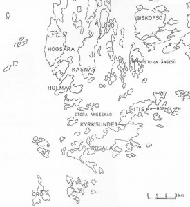
A thousand years ago the Vikings often traveled by the Eastern Route to the huge marketplaces in Novgorod, Constantinople and Baghdad. The route passed through the outer archipelago, and the strait between Hitis and Rosala, called Örsund, was an important harbour and marketplace.
A document from the thirteenth century describes a waterway, probably the same one used by the Vikings during the years 800-1000. The route goes from Arholma in Sweden to Åland, and from there continues through the southernmost part of the archipelago of Åboland to Hanko and the archipelago of Nyland. From Porkala, the route extends to Reval, i.e. Tallinn. The Vikings used this route as well, but their destinations were the Black Sea or the Caspian Sea. The document lists the the names of the locations, but has no exact information on distances or directions. Suitable harbours are noted, as are convenient places to spend the night or wait for favourable winds. In summer, the people living along the coasts traded with the numerous strangers traveling along the Eastern Route. Trading was conducted in the outer archipelago, in no man’s land, as villages and houses on land were badly protected against attacks and people were hesitant to let greedy guests close to their homes. Travelers bought foodstuffs and piloting services, as the waters were treacherous for anyone who didn’t know the route.
The archipelago offers a unique blend of wild nature and a cultural landscape formed by humans. The thousand-years of inhabitation and even older history have left their mark everywhere. When you travel in the footsteps of the Vikings, you experience history in the same barren, fascinating, beautiful scenery that once greeted them. The memory of Vikings who settled down on various islands lives on in legends and names of locations along the Eastern Route.

The marketplace and harbour at Kyrksundet
Archaeological examinations done around Kyrksundet during the years 1992-1996 are considered revolutionary when it comes to archeology in the archipelago, and have in many ways changed our perception of the history of human inhabitation of the archipelago. All observations indicate that the northern shore of Kyrksundet may have been a frequented harbour and marketplace as early as the ninth century.
In a part of the more than 500 m long site, workshop-related finds were discovered: pieces of bronze, bars for casting, glass, broken pearls, flint, numerous small sharpening stones, amber, and small pieces of silver, mostly coins cut into pieces. Based on the fragments of coins, it has been determined that the workshop was active during the end of the eleventh century.
High concentrations of phosphorus have been found along the old shoreline, which indicates that large amounts of fish were handled here. Iron rivets with diamond-shaped heads, typically used for Viking Age shipbuilding, point to ships having been built or at least repaired here as well.
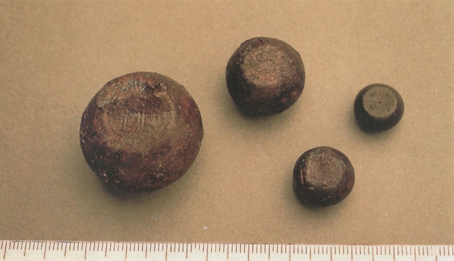
Among objects related to commerce, some thirty plummets, found scattered in the terrain, are worth mentioning. That these were used, among other things, for weighing silver, is indicated by the many pieces of coins discovered. One of the coins found had been minted in North Africa as early as during the eighth century. The others are mostly from the end of the ninth century and the beginning of the tenth century.

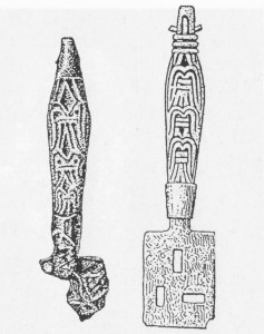
Finds from Kyrksundet also include a rich assortment of personal jewelry and accessories. Examples are horseshoe-shaped buckles (one of the more rare variants is a tenth-century Gotland-type buckle), arm rings with Scandinavian and Baltic shapes, fragments of oval buckles, pieces of chains and pendants, a West Scandinavian ring needle, fragments of a twisted neck ring, a key-shaped pendant and tweezers. Three bronze handles for keys intended for padlocks are especially interesting–similar ones have been found at Birka in Mälaren and in Viking Age graves on Gotland.

Ornated bronze handles for keys for Viking Age padlocks. The perforated blade is made of iron. The handle to the right is from Birka and the handle to the left is from Kyrksundet. If you look closely you can find the falcon which inspired the Viking Centre logo!
Increased well-being and growing private wealth during the Viking Age also increased the significance of the key and lock. The key did not only provide security, it was also a status symbol signifying worldly and spiritual power. The symbolic function is reflected in the fact that key-shaped pendants, resembling keys but without practical function, were used. One of the most well-preserved finds from Kyrksundet is a key-shaped pendant with a chain.
At the highest point of the excavation site, a spot 8-9 meters over the sea dominated by large erratic blocks, a real treasure was found during the years 1994-1995. Among the things discovered here was a pretty round Finnish buckle and below this a handful of bronze spirals from a womans belt. The belt has likely been wrapped around the buckle, which was, oddly enough, inserted under a small stone between a couple of larger ones. A few meters away, a rusted Viking sword blade, a Viking Age spearhead and a pommel were found. Another buckle, a ring needle, a fragment of a large gilded dress pin as well as a unique bronze dress pin were discovered in good condition some ten meters from there.
None of these items can be said to originate in a grave or a settlement or be associated with commerce; they have been hidden on purpose, possibly sacrificed. In other words, these mysterious finds indicate that Kyrksundet may have had served other functions than as a harbour and marketplace.
The runestone fragment on Stora Ängesön
One of the most interesting Viking Age finds in the Hitis archipelago is a runestone fragment which was found in 1997 off the shore of Stora Ängesön north of Hitis. The fragment appears to be the upper corner of a larger runestone and is made of jotnian sandstone. In the middle of the stone, there was an animal figure in relief and along the edge there are two parallel rows of writing, following the contour of the stone. The text is very fragmented and hard to interpret–eight runes remain of the text in the outer loop and seven in the inner one–but apparently contains the male name Torfast, which is found in 17 Viking Age rune passages, of which two are from Denmark, the rest from Sweden. The site of the find is located next to a strait which, during the Viking Age, existed at what is now Storfladan between Stora Ängesön and Lilla Ängesön. The seabed in the area was examined by divers from the National Board of Antiquities, but visibility on the shallow, muddy bay floor was close to nothing and no new observations illuminating the origin of the stone were made. How it wound up by Stora Ängesön, which ought to have been an excellent anchorage, is a mystery which may never be solved.
As the fragment is so small, it is possible that it was transported there, either aboard a boat which sank or in a load of stones on a sled which fell through the ice. Where such a journey started cannot be determined. Of course, it is also possible that the runestone stood on Stora Ängesön and fell into the water below the relatively steep slope of the shore. Only if more parts of the stone are found can its place of origin be determined more precisely.
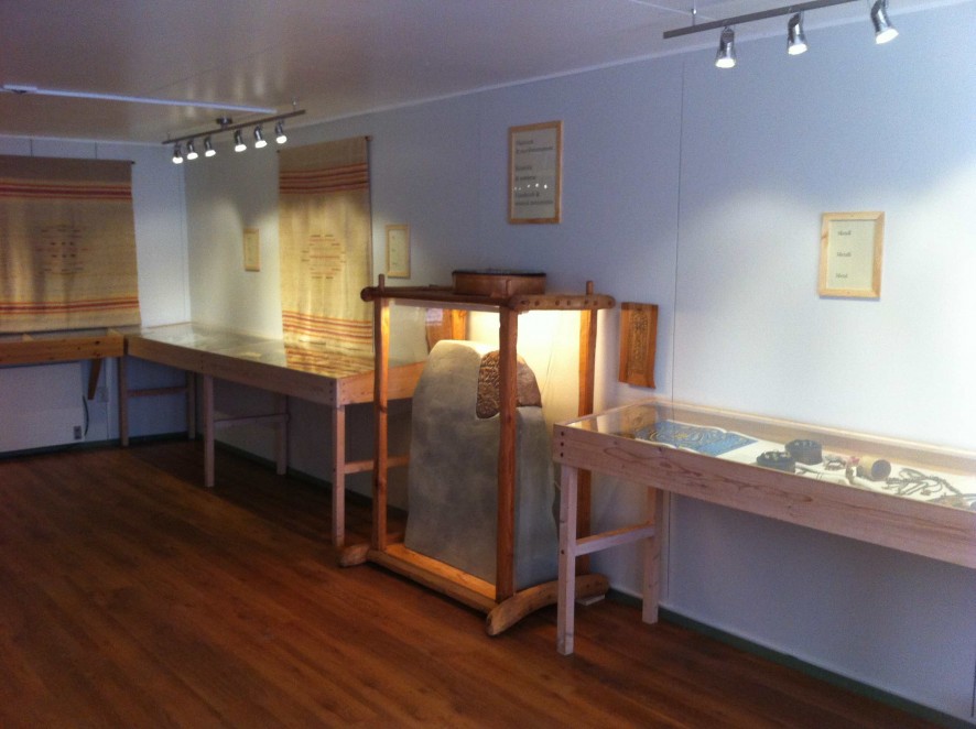
A cast of the so-called Hitis stone, where the likely size of the original stone is visible, can be seen in the crafts and instruments exhibition at the Viking Centre.


 Menu
Menu 


